New islands emerging in Arctica are undoubtedly a clear sign of climate change affecting the northern regions of our planet. Geographers from the Jagiellonian University study these significant global processes.
The Arctic. The climate is warming up. The glaciers are receding, as the sea is entering what used to be their domain, taking over areas of land below its level and carving out new islands. This isn’t a forecast for the future but the scenario which is unfolding now before our very eyes. During the recent decades, several dozen new islands have emerged in the vicinity of Greenland and in the European part of the Arctic alone.
This process has been analysed by Prof. Wiesław Ziaja and Dr Krzysztof Ostafin from the JU Institute of Geography and Spatial Management.
 The researchers have studied satellite photographs from dozens of archives as well as topographic maps from Denmark, Norway, Canada, and the USA. They’ve also made two journeys to Spitsbergen, where it’s possible to watch an ongoing process of the creation of a large island (almost 1,300 square kilometres in area) and a navigable strait. Their expedition and research is presented in a short movie (available below) and in the prestigious journal Ambio, published by the Royal Swedish Academy of Sciences.
The Isle of Warming
Prof. Ziaja and Dr Ostafin confirm that 34 new islands with an area of at least 0.5 km2 each have emerged since the 1960s, most of them (26) at the coast of Greenland, especially near its western end. Six islands appeared in Franz Joseph Land and Novaya Zemlya archipelagos in the European part if the Arctic, belonging to Russia, and one at Svalbard archipelago.
Some the “newborn” islands are quite big. Hall in Franz Joseph Land is 59 square kilometres in area. Hovgard Kystland and – suggestively named –Warming, both next to Greenland, cover an area of 31 km2 and 19 km2, respectively.
The figure shows a simplified model of transformation of the Arctic coast. The global warming and glacier recession lead to the creation of new islands and straits.
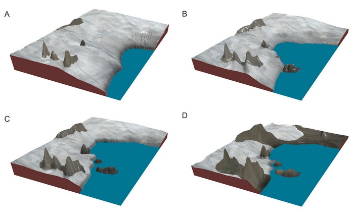 At the first stage (A), the whole coast is covered by a glacier. It contains nunataks, that is, exposed peaks or hills surrounded by ice. This situation remained unchanged until the mid-20th century. At the next stage (B), which depicts situation from the second half of the 20th century, the glacier shrinks, revealing parts of a rocky coast, partially free from ice, but linked to the mainland by the glacier. During the following phase (C) - the vital one – the ice connection between mainland and the rocky capes and peninsulas disappears. The areas below sea level are submerged by the ocean, which leads to the creation of an island and a strait. This is what happened at the turn of the centuries. Finally, in the 21st century (D), we can see that most of the coast is free from the ice, and the glaciers become separated into smaller parts, due to the significant decline in the thickness of the ice. Generally speaking, this process is going on along thousands of kilometres of the Arctic coasts
The islands of the (near) future
According to the researchers, “the pace of emergence of new islands has accelerated in the 21st century. 6 of them were created before 1980, 12 between 1980 and 2000, and as many as 15 after 2000. Three new islands appeared in just two years, 2016-2017. The process will only intensify.” They provide the example of a large part of land at the east coast of Greenland (Dove Bay), which can become a 200 square kilometre island as early as in 2018.
 The most interesting example of the current formation of postglacial islands comes from Ziaja and Ostafin’s research on Spitsbergen. In the southern part of this land they have observed a very quick withdrawal of a glacier from the isthmus between Hornbreen and Hambergbreen. As the width of the isthmus decreases by 270 metres each year, it can be estimated that it will completely disappear under water around 2035.
According to the researchers, the process of island formation leads to significant changes in the landscape and ecosystem of the entire Spitsbergen, including a different circulation of air masses, as well as altered routes of animal and plant migrations.
The phenomena described by Prof. Ziaja and Dr Ostafin provide important arguments that should be taken into account in the discussion about the global warming.
Original text by Piotr Żabicki: www.nauka.uj.edu.pl
-------------------------------------------------
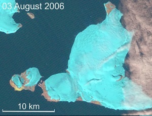
Map: new Arctic islands identified by the JU researchers
Animation: transformation of a coast into new islands – Hall island (no. 5 on the map, 1971 – 2017)
Articles:
Origin and location of new Arctic islands and straits due to glacial recession.
The studies were funded by the Polish Ministry of Science and Higher Education and the Prince Albert II of Monaco Foundation